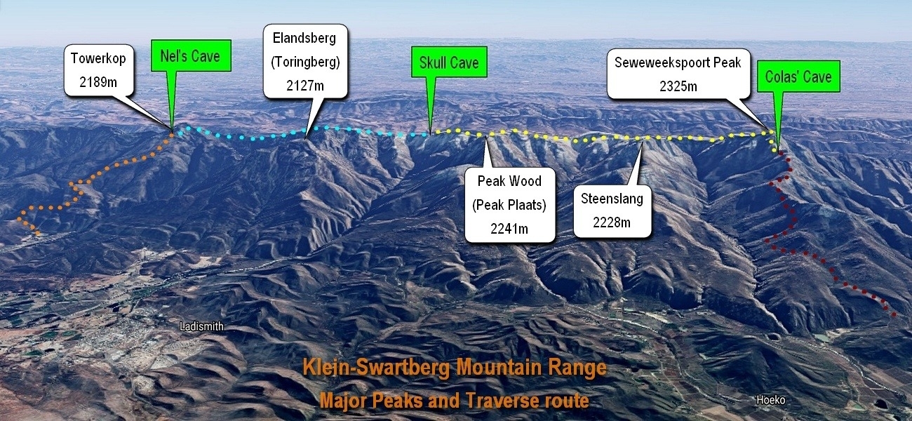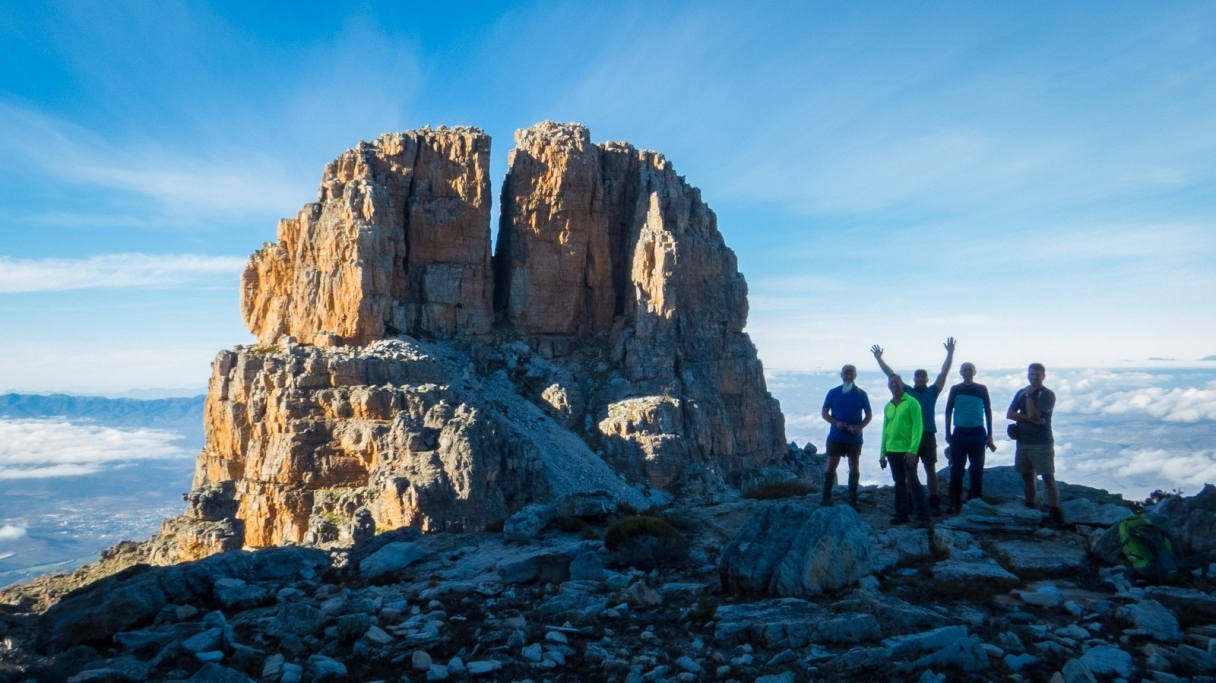
KLEIN-SWARTBERG TRAVERSE (Seweweekspoort Peak to Towerkop, or vice versa)
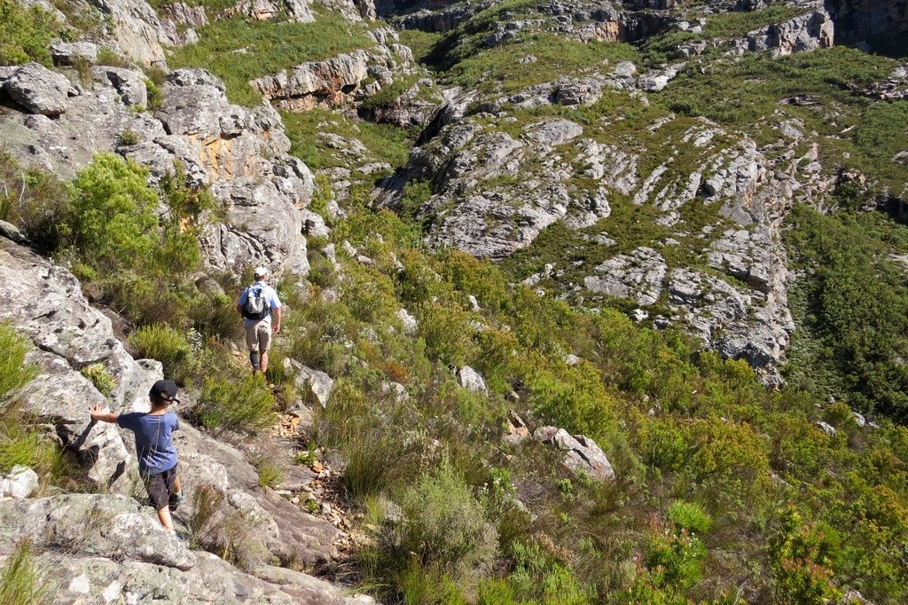
Important: this is a strenous hike over very difficult terrain, mostly without a path. During the winter months snow, ice and extremely cold weather may be experienced.
The route is close to 40km and is usually done over 4 days. It roughly follows the ridges and hills of the Klein-Swartberg mountain range between Seweweekspoort Peak and Towerkop, or vice versa. Many of the mountain areas covered in the Traverse are the property of the Mountain Club of South Africa and private individuals. Access permission is required from the MCSA's convenor of these properties, Mr Jan Viljoen, at: kleinswartbergbookings@gmail.com or Whatsapp: 083 698 2973.
Additional access arrangements for crossing and parking on farmers' properties:
- Please click here for important access information for the Hoeko (south) route.
- Please call Mr La Grange Volschenk on 028-5512037 or 083 378 1040 to cross his farm at the base of Towerkop.
- Please call Mr Fritz Hunlun on 076 600 1113 for use of the Northern (Vleiland) section in an emergency (or intentionally).
Day 1 [6-8 hours, ±10.4 km]:
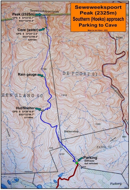
Start from Mr. Charl Nel's farm and hike up to Colas' Cave (Seweweekspoort Peak's cave) at S 33°24'12.6" E021°22'09.5'' ±2015m, where water can normally be found again in small puddles about 10m from the cave.
Day 2 [10-12 hours, ±10.6 km]:
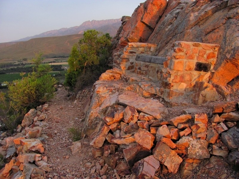
From Colas' Cave a very steep gully goes up between the cave and a large prominent leaning rock. Follow the stone beacons (and GPS) for about 2 to 3 hours to the summit (2325m). Continue roughly westwards along the ridges to Skull Cave roughly at S 33°24'06.9'' E021°16'35.9'' 1895m. This is a very strenuous day and an early start will be to your advantage. A small water hole inside Skull Cave might provide water, but is unfortunately NOT reliable. A direct descent of about an 01H30 should bring one to a small stream (S33° 23' 40.2" E21° 16' 33.6") to fill up again.
Day 3 [6-8 hours, ±8.5 km]:
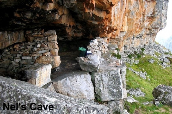
From Skull Cave continue westwards to Nel's Cave (Towerkop's cave) at S 33°25'25.4'' E021°12'24.8'' 1998m.
Day 4 [4-6 hours, ±8.3 km]:
From Nel's Cave take the hiking trail down to Mr. Volschenk's farm, called Bo-Buffelskloof.
The above Traverse can of course also be done the other way round, from Towerkop to Seweweekspoort Peak.
Other hiking routes & day trips around Ladismith
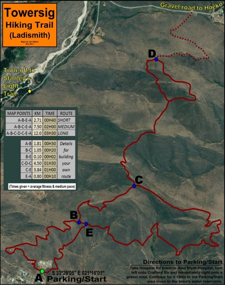
DAY TRIP: Towersig Hiking Trail (not to be confused with Towerkop's trail)
The Towersig (meaning "Magic View") hiking trail is situated in the foothills of the Klein Swartberg mountains just north of the town of Ladismith. The route consists of various short sections that can be done separately as comfortable strolls, or by combining these, a somewhat more challenging route of up to 12 km can be created. Spectacular 360º views of Ladismith and vicinity can be enjoyed, including the entire Klein Swartberg range - amongst others the famous Towerkop and Seweweekspoort Peak (highest in Western Cape - 2325m). To the south the Langeberg range guards the peak of Sleeping Beauty, and towards the west Touwsberg and Anysberg tower above the Karoo plains. Normally no running streams will be found on the route and it is recommended to carry water on the longer sections, especially during the summer months. No formal reservations are necessary.
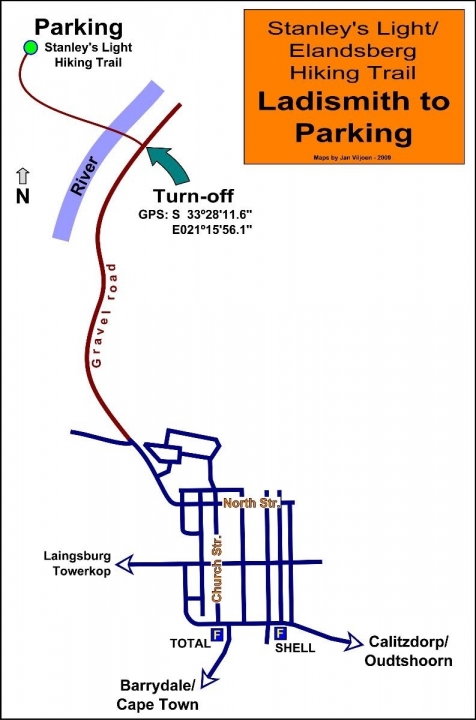
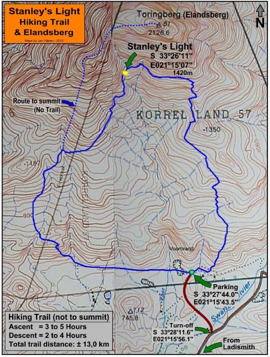
DAY TRIP: Hike to Stanley's Light
Stanley de Wit first installed his now famous light on Elandsberg (a.k.a. Toringberg) on 31 May 1963. During several trips up the mountain he came upon the idea of installing a light that can run on the perennial water coming down some steep rock faces. Stanley carried cement, electric cable and plastic pipe up the mountain to install the light. A small dam collected water higher up and via the plastic pipe, water was directed onto a wheel connected to a bicycle dynamo, which provided electricity to the light.
After maintaining the light for 30 years and undertaking 278 trips, the job was taken over from Stanley by local volunteers. The bicycle light was later replaced by two 24V truck lights and the dynamo by an alternator. A solar panel was installed as well to start the alternator again after periods of drought. The Stanley's Light trail (also known as the Elandsberg trail) is a popular day hike and can be completed within 5 to 9 hours. Some steep sections will be encountered and a good fitness level will be to your advantage. Going up via the western (left on the map) part of the trail one might cross two streams, but don't rely on these for drinking water during the summer months. No streams will be crossed on the eastern (right) approach. If Stanley's light can be seen burning (night before/early morning) you'll obviously be able to replenish your water supply there.
The trail is open to the public, free of charge. Please do not leave any rubbish behind and don't fiddle with any part of Stanley's light. As with any hike, leave your details with a relative/friend/guesthouse who can contact emergency services if you get in trouble. Cellphone coverage can be expected on most parts of the trail. The summit of Elandsberg can be reached by following the route indicated on the map (blue dotted line). No trail exists here and a few hours' steep climbing will bring one to the summit with excellent views towards nearby peaks and valleys. This route can be done as a long one day trip or a sleepover, providing a tent is available in case of bad weather (no caves).
Note: On Sunday 14th of October 2012 Oom Stanley de Wit passed away at the age of 86 years. He will be dearly missed as a true local legend.